River Ingrebourne Part 1
by Josh Anthony; first published 22-Aug-2025

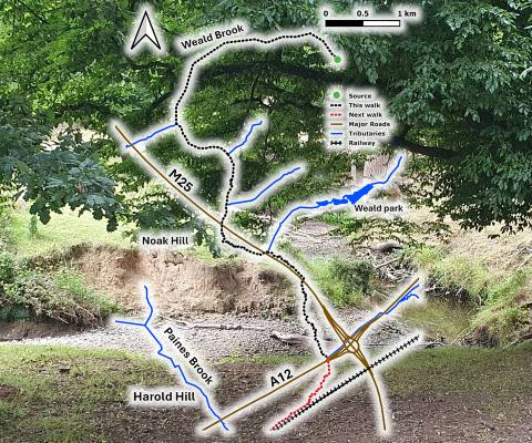
A sketch map of the walk - Josh Anthony
Like most rivers in Havering, the Ingrebourne is classified by the Environment Agency as moderate in ecological status. It was also a strategic waterway in the London Plan's Blue Ribbon Network. But these are just snapshots of a lifegiver that spans, forms, and divides geographies. A walk along its course from the headwaters in the South Weald hills should paint a clearer image.
The river makes a promising start as the Weald Brook in the Mores, a mature woodland in Bentley. Bars of flint pebble deposits from a long-ago ice age shine a jet-black lustre along the riverbed. It wiggles amongst dapples of light breaking through the beech and hazel canopy. Freshwater invertebrates would love these diverse habitat opportunities.
Its unbridled sinuosity soon however comes to an end as the river is forced into an overdeepened channel that runs straight-as-an-arrow alongside an oat crop. These watery strait-jackets have been a typical challenge facing our rivers ever since the intensification of agriculture and widespread land drainage. Uniform and disconnected from its floodplain, the river is bereft of the natural processes and variety in which its flora and fauna flourish.
Beneath the drier hilltops, the trees give way to more oaks and willows. There is also an abundance of Himalayan balsam, a non-native invasive plant that was introduced to the UK by Victorian gardeners, and has since spread along our river networks, dominating local species. "Balsam bashing" is a cathartic pastime of river volunteers around the UK, although care must be taken to get the balsam sprouts early enough that their spring-loaded mechanism cannot disperse the seeds further!
After a brief stint in concrete prison, the river emerges from a culvert beneath the M25 in Dagnam Park among herds of deer and strays from Maylands Golf Club. Here it enjoys the coverage of mature bankside trees that have occasionally toppled into the river. Woody debris was once seen as a hazard to be cleared immediately, but is now recognised as an important feature in creating diverse habitats. They cut a quaint scene among the eroding sandy banks of the Ingrebourne as it approaches the site for the in-progress A12 sliproad, itself a large and grey meandering tributary soon to be flooded in new traffic.
From here, the Ingrebourne joins the London Loop walking network and looks to take on new challenges on its course to the Thames.
to be continued...
![[Earth icon]](../emblem64.jpg)